Storage Facilities
WATER BANK STORAGE FACILITIES
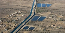
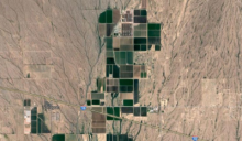
The Arizona Water Banking Authority (AWBA) partners with several water storage facilities and holds water storage permits with the Arizona Department of Resources (ADWR) at each of these facilities. The AWBA stores water at Underground Storage Facilities and Groundwater Savings Facilities within the Phoenix, Pinal and Tucson Active Management Areas (AMAs). When excess Central Arizona Project (CAP) water is available, the AWBA coordinates with the Central Arizona Water Conservation District (CAWCD) for the delivery of these supplies to various storage facilities. The location of storage depends on the availability of funding sources and capacity at each facility.
NEW MAP! - The new AWBA interactive GIS map includes more details on each facility and includes a feature to download the dataset.
PHOENIX AMA
UNDERGROUND STORAGE FACILITIES
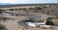
Granite Reef Underground Storage Project
The Granite Reef Underground Storage Project (GRUSP) was developed in partnership with nine cities to store water from a variety of sources and enable Arizona to maximize the use of its Colorado River entitlement. GRUSP is operated by SRP and owned by Salt River Pima-Maricopa Indian Community, SRP, Chandler, Gilbert, Phoenix, Mesa, Scottsdale and Tempe.

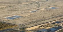
Agua Fria Recharge Project (Constructed)
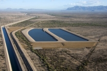
Owned by Central Arizona Water Conservation District. Operations began in May 2002 and construction costs were $10.5 million. Infiltration rates: 2-4 feet per day, Number of basins: 7, Basin infiltration area: 38 acres
Turn-out Type: Gravity 350 cubic feet per second; operated at 150-175 cubic feet per second.
Hassayampa Managed Recharge Facility
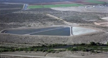
Hieroglyphic Mountains Recharge Project
Owned by Central Arizona Water Conservation District. Operations began in January 2003 and construction costs were $5.7 million. Infiltration rates: 3 feet per day, Number of basins: 7, Basin infiltration area: 38 acres, Turn-out Type: Pump 100 cubic feet per second.
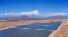
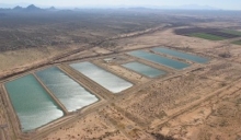
Tonopah Desert Recharge Project
Owned by Central Arizona Water Conservation District. Tonopah Desert Recharge Project (TDRP) operations began in January 2006 with a construction cost of $13 million. Infiltration rates: 4-5 feet per day, Number of basins: 19, Basin infiltration area: 207 acres, Turn-out type: Gravity turnout 300 cubic feet per second.
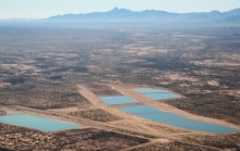
Superstition Mountains Recharge Project
Owned by Central Arizona Water Conservation District. Operations began in June 2011 and construction costs were $10 million. Infiltration rates: 5-6 feet per day, Number of basins: 2, Basin infiltration area: 38 acres, Turn-out Type: Pump 150 cubic feet per second.
GROUNDWATER SAVINGS FACILITIES
Chandler Heights Citrus Irrigation District
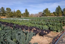
Founded in the 1920's, Chandler Heights Citrus Irrigation District is a 1,460 acre area of Maricopa County, southeast of Phoenix, Arizona. The district is responsible for supplying irrigation and drinking water to over nine hundred households in the district. There are still commercial citrus groves in operation, but now the majority of the district is residential.
Maricopa Water District
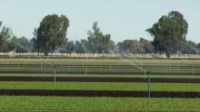
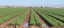
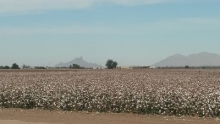
The Maricopa Water District (MWD) started in 1927, as a political subdivision and an irrigation and water conservation district. MWD provides water to service an area of approximately 60 square miles. The lands within MWD which are still in agricultural production are cropped with cotton, vegetables, fruits, citrus, grapes, and grain.
New Magma Irrigation & Drainage District
New Magma Irrigation & Drainage District (NMID) began in June 1995 and is located West of Phoenix, between Queen Creek and the Gila River in Maricopa and Pinal Counties, Arizona. It is composed of 27,410 acres, of which 26,900 are irrigable acres.
Queen Creek Irrigation & Drainage District
Constructed in 1985, the Queen Creek Irrigation and Drainage District (QCIDD) services nearly all of the city of Queen Creek and its neighboring areas; as well as supplementing the Chandler Heights Citrus irrigation. QCIDD stretches east from Power Road to Schnef Road, and south from Germann Road to Hunt Highway, encompassing around 23,000 acres, 16,000 acres of which are irrigable.
Salt River Project GSF
Large municipal water providers in the Phoenix AMA participate in SRP’s Groundwater Savings Facility. Water providers deliver Central Arizona Project water from the Colorado River to SRP in lieu of pumping groundwater.

Roosevelt Water Conservation District
Roosevelt Water Conservation District (RWCD) is an irrigation district located just to the south and east of Chandler and Gilbert. RWCD began in the 1930 when it paid the costs to concrete line 31 miles of SRP’s major canals and received SRP surface waters that would otherwise have been lost to seepage from dirt canals. In 1992, RWCD became one of the first irrigation districts to recharge excess Colorado River water.
Tonopah Irrigation District
Tonopah Irrigation District is located in Tonopah, Arizona, the western most portion of the Phoenix AMA.
Gila River Indian Irrigation & Drainage District (Phoenix)
The Gila River Indian Community (GRIC) is an Indian reservation located in south central Arizona and spans both the Phoenix and Pinal Active Management Areas. It borders the south side of the city of Phoenix and stretches into Pinal and Maricopa County.
PINAL AMA
GROUNDWATER SAVINGS FACILITIES
Central Arizona Irrigation & Drainage District
Central Arizona Irrigation & Drainage District (CAIDD) was formed in 1996 and is located in and around Eloy, Arizona. CAIDD is composed of 87,586 acres.
Hohokam Irrigation District
Hohokam Irrigation & Drainage District (HIDD) was formed in 1972 and is located Northeast of Casa Grande, southwest of Coolidge in Pinal County, Arizona. It is composed of 29,600 acres, of which 28,200 are irrigable acres.
Maricopa Stanfield Irrigation & Drainage District
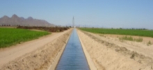
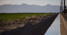
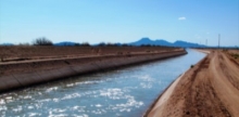
Maricopa Stanfield Irrigation & Drainage District (MSIDD) formed in 1962 to provide irrigation water for agricultural use. The District is located in Pinal County, Arizona just west of Casa Grande, AZ. The irrigation system involves over 200 miles of distribution concrete-lined canals and laterals. MSIDD receives its surface water from the Central Arizona Project .
Gila River Indian Irrigation & Drainage District (Pinal)
The Gila River Indian Community is an Indian reservation located in south central Arizona and spans both the Phoenix and Pinal Active Management Areas. It borders the south side of the city of Phoenix and stretches into Pinal and Maricopa County.
TUCSON AMA
UNDERGROUND STORAGE FACILITIES
Avra Valley Recharge Project
Central Avra Valley Storage and Recovery Project
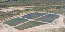
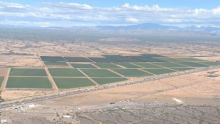
The Central Avra Valley Storage and Recovery Project (CAVSARP) includes 11 recharge basins and totals 317 acres. It is located west of Tucson in Avra Valley. The City of Tucson purchased this land in the 1970s with the intent of retiring the property from agricultural use. In the mid-1990s, Tucson Water began storing Colorado River water via the CAP canal.
Pima Mine Road Recharge Project
Owned by Central Arizona Water Conservation District. Operations began in December 2001 with a construction cost: $11 million. Infiltration rates: 1.9 to 5.8 feet per day, Number of basins: 5, Basin infiltration area: 23 acres, Turn-out Type: Gravity 90 cubic feet per second.
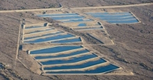
Lower Santa Cruz Recharge Project
Owned by Central Arizona Water Conservation District. Operations began in June 2000 with a construction cost of $3.9 million. Infiltration rates: 2.5 feet per day, Number of basins: 3, Basin infiltration area: 38 acres, Turn-out Type: Pump 65 cubic feet per second, Annual permitted volume: 50,000 acre-feet.
Southern Avra Valley Recharge Project
Southern Avra Valley Storage and Recovery Project (SAVSARP) includes 9 recharge basins and totals 226 acres. It is a sister project to the Central Avra Valley Storage and Recovery Project, owned and operated by Tucson Water to fully utilize Tucson’s allocation of Colorado River water.
GROUNDWATER SAVINGS FACILITIES
Cortaro-Marana Irrigation District
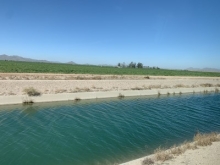
Cortaro-Marana Irrigation District (CMID) serves the agricultural irrigation needs of the Marana, Avra Valley and Cortaro communities. The District owns approximately 65 miles of pipelines and concrete canals, providing irrigated water to more than 12,000 acres of farmland.
Kai Farms (Red Rock)
BKW Farms